


Tour de la montagne d'Aujour

PatriceCocuaud
Gebruiker

Lengte
22 km

Max. hoogte
1572 m

Positief hoogteverschil
888 m
Km-Effort
34 km

Min. hoogte
798 m

Negatief hoogteverschil
887 m
Boucle
Ja
Datum van aanmaak :
2019-10-01 15:03:23.376
Laatste wijziging :
2019-10-01 17:49:39.985
2h40
Moeilijkheid : Medium

Gratisgps-wandelapplicatie
 SityTrail
IGN / Geografische instituten
SityTrail Plus
De wereld gaat voor u open
Over ons
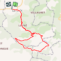
Tocht Mountainbike van 22 km beschikbaar op Provence-Alpes-Côte d'Azur, Hautes-Alpes, Le Saix. Deze tocht wordt voorgesteld door PatriceCocuaud.
Plaatsbepaling
Land:
France
Regio :
Provence-Alpes-Côte d'Azur
Departement/Provincie :
Hautes-Alpes
Gemeente :
Le Saix
Locatie:
Unknown
Vertrek:(Dec)
Vertrek:(UTM)
723945 ; 4928597 (31T) N.
Opmerkingen